It's a really nice map, but that's not what I'm posting about. Because it's from an atlas, it has text on the back for use in school geography lessons. Colton's atlas was printed in New York, so the text is from a US perspective. The text on the back concerns the British Empire (which is odd right away, because we didn't formally have an empire until 1876 when Victoria became an empress (of India) in addition to being a queen).
The article ends with some interesting statistics.
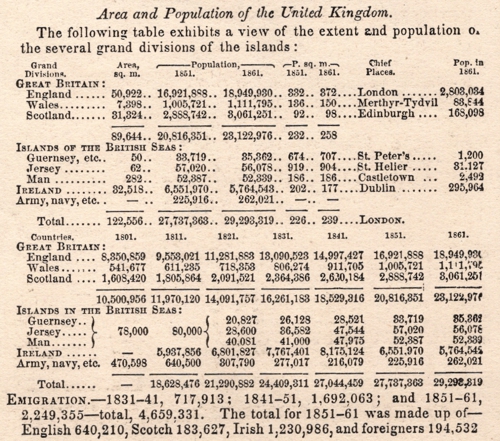
Irish emigration was 1,230,986 in the decade 1851-1861. "Irish" here would mean people born anywhere in the whole island or Ireland, and include Irish people who had migrated from there to other parts of the UK (my paternal grandather's maternal grandparents among them). This decade missed most of the potato famine (which ended about 1852), but it doubtless played its part. To this day, Ireland still has a lower population that its size, georgraphy and climate might suggest.
I can't get over the note that the chief place in Wales is Merthyr-Tydvil, though. That looks as if it's one of those deliberate changes that map-makers put in their creations so they can prove when it's been ripped off....